logo
Search John Harvey Photo for...

Advanced Search...

Click on map to center, zoom in:
Select the Map:
map map map
map map map
map map map
about map data... Centered at -127 36' 28'', 50 51' 46'',
Map Width: 2 3 4 5 6 7 8
556m per pixel
278m per pixel
139m per pixel
69m per pixel
34m per pixel
17m per pixel
 Map Height:
  2
  3
  4
  5
  6
Scarlett Point Lighthouse Beach Side At Camp Site Pultney Point Lighthouse With Fog Horns Bikes Loaded On Ferry
Scarlett Point Lighthouse

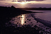
I used a 2 times teleconverter and the lens was set in the 300mm range. I used a tripod and fired
when the curve was at the height or bottom of it's yaw. I really like the colors that came through.
The has really including some journal entries.
It looks the light house still has

John Harvey Photo > Mid Coast of BC on the Curve of Time > Hanson Island to Nigeil Island > Scarlett Point Lighthouse

Beach Side At Camp Site Beach Side At Camp Site
Tags: beach
John Harvey Photo > John's Overnight Page > North Island > Beach Side At Camp Site

Pultney Point Lighthouse Pultney Point Lighthouse
John Harvey Photo > John's Overnight Page > Port McNeill And Area > Pultney Point Lighthouse

Pultney Point Lighthouse With Fog Horns Pultney Point Lighthouse With Fog Horns
John Harvey Photo > John's Overnight Page > Port McNeill And Area > Pultney Point Lighthouse With Fog Horns

Bikes Loaded On Ferry Bikes Loaded On Ferry
John Harvey Photo > John's Overnight Page > Port Mc Neill > Bikes Loaded On Ferry