Baden Powell Trail

 One of the four major sections
It's 44km - approximately 14 hours - from end (Deep
Cove) to End (Eagle Ridge) and it pretty much skirts the edge
(sometimes enveloped) by the urban sprawl of Vancouver. The
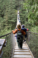
grouse grind shares 200m of it, as does a Lynn Canyon Suspension
Bridge. It's the Baden Powell Trail and it's hike-able most of the
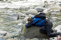
year round. David and I had an afternoon to burn and decided to
take on the section from Lynn Canyon to the base of Grouse
Mountain.
One of the attractions for me is that we can take transit to various
points along the trail. We took the bus to Lynn Canyon and began
our hike by going backward - out over the suspension bridge.
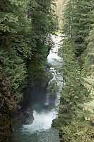
Lynn Canyon has always been a favorite just because it's so open.
Very early on in this hike it was apparent we would be taking a lot of
photos. Both David and I are camera people and there are lots of
things to take photos of.
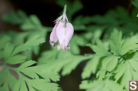
Vancouver area ecology has definite prime times for various types of
events. Late in the summer it's mushroom time. Mid summer
there are alpine flowers. Early summer there are low elevation
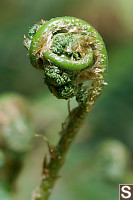
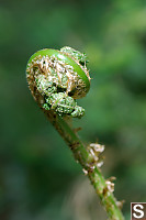
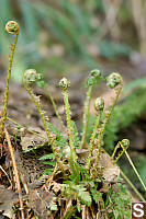
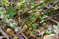
flowers and (as I discovered on this hike) new ferns growing
up. Bracken fern (in my opinion) is the most interesting as
it grows up.
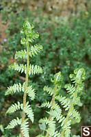
Sword
fern (the largest of the local ferns) is
somewhat more boring. Deer Ferns are by comparison tiny. As
I walked along I was always on the look out for new ferns but I was
under the mistaken impression that there are only three species of
local ferns.
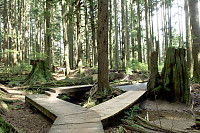
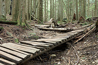
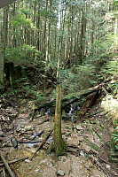
The trail itself is quite interesting. Unlike most trails around
here (up a mountain), the Baden Powell trail is often just the default
choice through a web of trails. Some sections of the trail are
dominated by mountain bikers and the constructions they like.
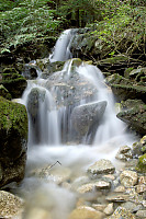
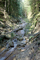
Water also dominates the trail. Every 15 minutes or so you will
cross some sort water feature - a small stream or a deep valley.
Flooding also influences the look of the trail - one section had a
thick layer of sediment laid down from an up stream flood.
Another valley was washed down to bedrock from flood.
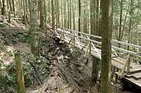
The trail is in some areas very well maintained - in other areas
wanting.
Lesters Bridge
over Abeland canyon is an example of an
old washed out
bridge that has been replaced with a very expensive aluminum
bridge.
In other parts of the bridge the washed out bridge has been replaced
with a large log.
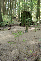
As you walk the length of the trail you can slowly feel the ecology
changing.
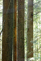
As we neared the
grouse end of the trail you get into
older and dryer timber.

The last 200 meters of shared trail are like a moon scape - the trail
is broad and very well worn. Welcome to the bast of the grouse
grind. We popped back into civilization and caught the bus down
the Seabus terminal and an awesome evening BBQ. What more could
you ask for?
Tags: fern(6), forest(5), trail(3), bridge(2), waterfall(2), tree(2)
People: David(1)
From: John Harvey Photo > John Harvey Photo - Hiking > Baden Powell Trail
I have been hiking on and around the b.p. trail and north of the water towers above skyline rd, I am looking for the turbine engine that fell from the sky in 1970 from a commercial airliner and the engine impacted the earth in this area , I have made 2 attemps now.
anyone out there with a good sence of its whereabouts ? or a detailed map ?
dan
Saturday, September 22nd, 2007 at 19:34:29
does anybody know where the Baden Powell trail picks up from Grouse Mountain (towards the west)? thanks!
sideshowpercy
Wednesday, August 20th, 2008 at 01:20:00
Probably a bit late to respond, but yeah, it follows down through the houses (not very exciting) and then you can get back on it at the dam.
ME
Sunday, March 15th, 2009 at 22:51:59
hey i think i know what your talking about if your still looking for it and haven't found it its somewhere on the top of fromme mountain way after the dump almost on grouse mountain . wayyyyyyyyy above the Baden Powell, you'll have no luck looking on that trail.
daniel
Thursday, November 12th, 2009 at 00:05:38
can anyone please tell me the exact point of entrance for the baden powell trail at the horseshoe bay end thank you
gary
Sunday, May 30th, 2010 at 19:09:40
"To reach the western trailhead for the Baden-Powell Trail, take Highway #99/#1 to Horseshoe Bay. There is parking for six cars at the base of the Black Mountain Trail, on the east side of highway #99, between the exit to the ferries and the bridge over to Marine Drive (Horseshoe Bay Village). The original location of the trailhead at Eagleridge Drive is no longer accessible due the re-routing of the Sea-to-Sky highway in 2008."
From the top of Westport Rd it's also possible to take the Whyte Lake Trail, which connects to the Baden Powell.
Here's a map showing the 2 trailheads:
http://westvancouver.ca/uploadedFiles/Parks_and_Environment/Activities/Walking_and_Hiking/Hikes/Whyte Lake Trail Map.pdf
jim
Monday, July 19th, 2010 at 15:05:58
Are you sure its an engine turbine that is on the trail, there was a famous plane crash in 1947 in that same area, somewhere near Mt. Elsay, near the Lynn Valley end of the B-P trail, it was discovered in 1994.
Cory
Sunday, October 31st, 2010 at 02:07:18
I've seen that engine turbine a few times, it's near the top of the hike that goes up the old chairlift path going up from skyline drive to the bottom of the cut. Always wondered what it was doing up there.
D
Thursday, September 13th, 2012 at 20:16:04
The jet engine on skyline trail on grouse is from a 1950s fighter jet crash.
www.clubtread.com/sforum/topic.asp?TOPIC_ID=19061
Joshnv
Monday, May 13th, 2013 at 09:41:56
Last Modified Saturday, January 21st, 2023 at 23:42:14 Edit
Copyright and Contact Information.