Alexander MacKenzie from Dean Channel
1 of 14 from Jenny Inlet to Cascade Inlet
Next

mainimage

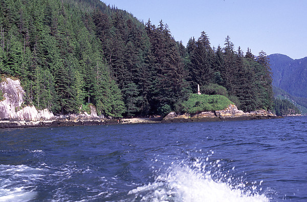
This is the view from the Zodiak as we pull around to Elcho Harbour where the
Curve of Time is parked (we couldn't anchor).  The beach (about the middle of the frame)
is where we pulled the Zodiak in and where the Petroglyph is.  The marker is on the hill
and the carving is in the rock bluff on the right.

Hi John, Thanks for the great pictures and maps. I was watching Canada a People's History. On the show they were not clear as to where Alex left his message on the rocks. Awesome! This site is now on my favorites list.
Brad Chalmers
Thursday, September 14th, 2006 at 11:55:05


Date: Tuesday, August 7th, 2001
Film: Fuji Velvia 50 (slide)
Lens: 28-70mm f/2.8 ED-IF AF-S Zoom-Nikkor
Location:
Alexander MacKenzie from Dean Channel Alex MacKenzie From Canada by Land 22d July 1793 Alexander MacKenzie from Dean Channel Alex MacKenzie From Canada by Land 22d July 1793 Alexander MacKenzie from Dean Channel Alex MacKenzie From Canada by Land 22d July 1793 Alexander MacKenzie from Dean Channel Diagonal Falls Hanging Valley Laying Anchor in Eucott Bay Eucott Hot Spring When we Arrived Alexander MacKenzie from Dean Channel Diagonal Falls Hanging Valley Laying Anchor in Eucott Bay Link Lake Dam at Ocean Falls Log Sorting Yard Alexander MacKenzie from Dean Channel Diagonal Falls Hanging Valley Cabin at End of Cascade Inlet Laying Anchor in Eucott Bay Curve of Time Driving By Link Lake Dam at Ocean Falls Log Sorting Yard Wharf in Namu Bella Bella from the Ocean Entrance to Codville Lagoon Logging Site on Doc Creek Alexander MacKenzie from Dean Channel Hanging Valley Cabin at End of Cascade Inlet Laying Anchor in Eucott Bay Curve of Time Driving By Evening Anchorage Wharf in Namu Bella Bella from the Ocean Entrance to Codville Lagoon Logging Site on Doc Creek Alexander MacKenzie from Dean Channel Cabin at End of Cascade Inlet Curve of Time Driving By Leather Star Flare Walking On We Log Wharf in Namu Alexander MacKenzie from Dean Channel Cabin at End of Cascade Inlet Curve of Time Driving By Evening Anchorage Leather Star Walking On We Log Pass By Jasper Athabasca Falls Closer Mount Robson In Fog New National Park Sign Yellow Iris With Ants Waiting For Lifts To Open Mark And Mike At Summit Boat At Landing Boardwalk In Meadow Rock Margin Front of Condo Fence at Rathtrevor Wharf in Namu Diagonal Falls New National Park Sign Waiting For Lifts To Open Mark And Mike At Summit Boat At Landing Front of Condo Wharf in Namu Immature Bog Cranberry Numa Falls (Veiled) Athabasca Falls Closer Bromley Rock Mount Robson In Fog Logging Site on Doc Creek Brown Nootsum River Alexander MacKenzie from Dean Channel Curve of Time Driving By Link Lake Dam at Ocean Falls Log Sorting Yard Wharf in Namu Cultus Sound Anchorage Bella Bella from the Ocean View of Shearwater Marina Entrance to Codville Lagoon Landing for Trail to Sagar Lake Logging Site on Doc Creek Alexander MacKenzie from Dean Channel Diagonal Falls Hanging Valley Wharf in Namu Bella Bella from the Ocean Entrance to Codville Lagoon Logging Site on Doc Creek Alexander MacKenzie from Dean Channel Hanging Valley Cabin at End of Cascade Inlet Laying Anchor in Eucott Bay Curve of Time Driving By Evening Anchorage Wharf in Namu Bella Bella from the Ocean Entrance to Codville Lagoon Logging Site on Doc Creek Alexander MacKenzie from Dean Channel Cabin at End of Cascade Inlet Curve of Time Driving By Leather Star Flare Walking On We Log Wharf in Namu Alexander MacKenzie from Dean Channel Cabin at End of Cascade Inlet Curve of Time Driving By Evening Anchorage Leather Star Walking On We Log Pass By Jasper Athabasca Falls Closer Mount Robson In Fog New National Park Sign Yellow Iris With Ants Waiting For Lifts To Open Mark And Mike At Summit Boat At Landing Boardwalk In Meadow Rock Margin Front of Condo Fence at Rathtrevor Wharf in Namu Diagonal Falls New National Park Sign Waiting For Lifts To Open Mark And Mike At Summit Boat At Landing Front of Condo Wharf in Namu Immature Bog Cranberry Numa Falls (Veiled) Athabasca Falls Closer Bromley Rock Mount Robson In Fog
Map
Tag: coast
Larger image: 2000 x 1317

John Harvey Photo > Mid Coast of BC on the Curve of Time > Jenny Inlet to Cascade Inlet > Alexander MacKenzie from Dean Channel
John Harvey Photo > John's Overnight Page > Mid Coast of BC on the Curve of Time > Jenny Inlet to Cascade Inlet > Alexander MacKenzie from Dean Channel

Leave a Comment

Some HTML allowed: <b>, <code> <em> <i> <strike> <strong>, but most isn't.  Text length is limited.  Comments from first time authors will be reviewed before being posted. Comments with swearing or painfully poor spelling will probably be rejected.

Last Modified Saturday, January 21st, 2023 at 23:39:03. Edit
Copyright and Contact Information.