Wells Gray

 One of BC's larger and lesser known parks
I've driven by Wells Gray a few times while driving from Jasper
down to Kamloops and wondered about the park. The Park has some
exposure - there are several guide books published for the park, and
I've met people who have been - more than I can say for most BC
parks. Helen
and I had some days off this summer and decided to go check the park
out.
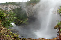
Spahats Provincial Park
It is impossible to get lost driving in Wells
Grey. There is a
single road in and it just goes deeper and deeper into the park.
When you turn off the highway (at Clearwater) you aren't yet in the
park - you have to drive 36km. Before you get to Wells Gray, you
pass through
Sphats Provincial Park.
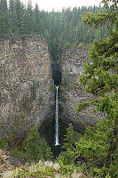
Spahats gives you a quick tutorial in how the
valley
is built. While you admire the waterfall, you notice the bands of
basalt (slowly cooled lava) in the cliff walls surround the bowl carved
by the waterfall. This whole
area is a layer cake of hard lava and softer layers which leads to hard
layers
supporting dramatic undercut water falls.
You can learn a second lesson about Wells Grey here too - it's easy to
walk to a viewpoint and see the falls. That said, it's quite hard
to take a unique picture in this park because your choice is either a
quick and easy viewpoint, or a multi hour walk to find a larger variety
of viewpoints. After our 20 minute stop in Spahats, we continued
toward Wells Gray.
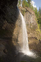
Helmcken Falls
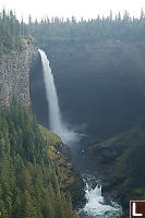
The start attraction of the park is Helmcken
falls.
This is one of the most dramatic falls in Canada and even though the
viewing platform is a long way away from the water, you are struck by
just how big this drop is and
how much water is going over it every second. If you don't
mind a bit of a walk (about 4km each way), you can walk to the rim on
the other side of the river (and get a much closer (and unguarded view
of the falls).
If you really want to do these falls justice,
you probably need to walk
up river to nearer the base of the falls - roughly a five hour return
trip. Even then, you want the right combination of sun (later
afternoon is apparently better) and weather (not foggy). Good
luck!
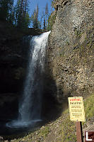
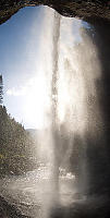
Moul Falls
I really like the return on investment on this
falls. It isn't a
a drive up falls and it isn't the biggest drop in the Park, but this
falls is the
most fun. After about 45 minutes of walking, you walk down stairs
to get to the base of the falls. From here you can walk around
behind the falls and watch the water come over your head to fall in the
pool. There aren't a lot of places this approachable.
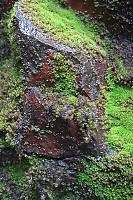
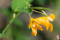
In the spray zone of the falls you get
different
species. Directly under the falls (where there is very little
direct light), the rocks are covered in moss and algae.
Just a little down river from the falls you see "stream bank" species
such as Cape Jewelweed - a plant I have never seen anywhere else.
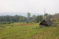
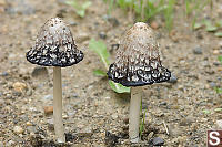
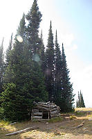
Ray Farm
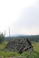
Beyond the drama of nature, there is a human
element
to Wells Gray. This area was settled by pioneers before this was
a park. Ray farm is what remains of the homestead started by John
Ray. He cleared the land, built several buildings and is buried
(with his wife) on the site. Hopefully, you won't be staying as
long.
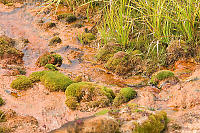
Located on the farm site is a large mineral
spring. The water bubbles up an leaves the ground a rust
colour. Moss grows closest to the springs, and just outside the
moss zone is a variety of lush plants that apparently attract large
grazers (not that we saw any). I could imagine that would be
quite handy to have around if you were running a farm.
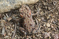
We went for a walk toward the other spring, about a km away. We
found toads (or more accurately, toadlets) crawling in the dirt around
the trails. These tiny toads (smaller than a dime) don't need to
live in the water and looking to finding good places live.
I've seen toads 5 times the length of these little guys - it surprised
me how much growing up they have to do.
In the dry conditions, we didn't make it to the next
spring. We decided to leave it for our next trip.
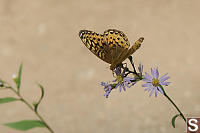
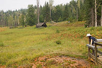
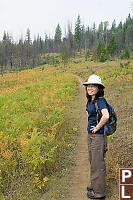
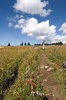
Trophy Meadows
Our guide book has a handy chart of which
flowers are blooming in which
month. By mid August, pretty much everything is done. End
of August was the time we had so we had to make the best of
it. Trophy Meadows isn't in Wells Gray (the turn off
is just after Spahats park) and you drive up the mountain through an
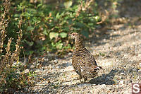
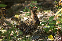
old clear cut until you get close to the parking lot. We came
across a Blue Grouse on the drive up and the birds are so confident in
their camouflage, you sometimes need to chase them off the road to get
to go by.
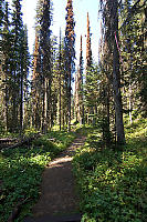
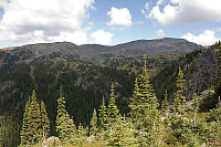
Once we parked and got on our hiking boots, we hiked up into the
unlogged forest. Pine beetle damaged trees are now common around
British Columbia and these high trees were no different.
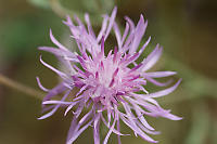
As suggested by the book, there were very few flowers (mostly Indian
paint brush and some asters). Even without flowers, the meadows
were
quite impressive.
Tags: waterfall(4), meadow(2), moss(2), trail(2), columnar basalt(1), tree(1)
People: Helen(1)
From: John Harvey Photo > John's Overnight Page > Wells Grey
From: John Harvey Photo > Blogs for 2025 to 2005 > Wells Grey
Last Modified Saturday, January 21st, 2023 at 23:48:36 Edit
Copyright and Contact Information.