
The Lions

 Yes, there is some vertical
The Lions overlooking Vancouver are our
geographical
landmark if ever there is one. The hike up is fairly well known -
it's verticle and hard. Unfortuantly the lions are well known for
a third reason - every few years someone dies while trying to climb to
the peak. The most recent fatality was in the middle of
September (roughly 9 days previous) durring foggy conditions - the rain
covered granite was a slipperly slide to a long drop.
Helen wanted to see photos of the trip up and I didn't have any to
show. Some people like to tell stories about how ugly the
bathroom was on their last internation trip - other people don't
mention it. The trail up reminds me of that situtation. The
trail is roughly broken into three sections - a gravel road, a steep
assent through the forest and then an alpine section.
Seeing the Lions close up is quite startling. The seem smaller
than you might first think.

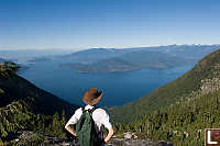
Besides the view to Vancouver, there is
also an open view up the sunshine coast. Langdale and
Gibsons is clearly visible as it Bowen, Keats and Gambier Island.
The Mountain on the right here (with the clear cut) is Mount Harvey,
named after John Harvey (my namesake) of the H.M.S. Brunswick.
What quite surprised me was what was visible behind the
lions. The very distinctive Black Tusk is visible (It's 100km
away) and the massive Diamond Head is also quite visible. Further
to the left is a glacier on the other side of Whistler.
So - about the danger? It's real. There are a lot of
granite outcroppings that are steady when dry but could be one slip
from disaster in rainy or snowy conditions. A trip organized by
work a few years ago (when there was still snow on the ground) resulted
in a broken ankle when someone slid down a steap slope and hit a
tree. The views are amazing - it's worth going when the weather
is nice (clear) and you aren't worrying about your footing.
Tags: vista(4), summit(2), hiking(2), coast(1), Vancouver(1), logging(1)
From: John Harvey Photo > John Harvey Photo - Hiking > Lions
From: John Harvey Photo > Lions
Wow just stunning photos. But how do you get there from Vancouver? Just wondering.
The man from Toronto
Wednesday, March 23rd, 2011 at 14:15:26
Short Answer - we drove. Lions Bay is a community on the way up to Squamish/Whistler - maybe 15 minutes past Horseshoe bay. You take the exit into the community and then drive up a bunch of residential (paved) roads until you get to the exit. (You need a map). Parking is tricky - there isn't much at the trail head and everything else wants to be tow away zone. Then you start walking...
Last Modified Saturday, January 21st, 2023 at 23:44:04 Edit
Copyright and Contact Information.


